By Jay · Updated November 2026
Coorg, or Kodagu, is a hill district in the Western Ghats of Karnataka, about five to six hours by road from Bangalore and one of the most popular weekend escapes in South India. It is coffee country first of all, with plantations spread across the hills under tall shade trees, and around them sit waterfalls, viewpoints, old temples and a couple of serious wildlife reserves, all within a fairly small area. The cool, damp weather and the rows of green hills are what earned it the nickname the Scotland of India.
This guide covers 25 of the best places to visit in Coorg, and for each one you get what it is, how to reach it, timings and entry where they apply, and the best time to go. After the places come a two-day itinerary, advice on the season, how to get here from Bangalore, where to stay, and the questions people tend to ask before a Coorg trip.
Quick facts:
Distance from Madikeri: about 8 to 10 km.
Timings: 9 am to 5 pm.
Entry: around 15 -20 rupees per person, parking charged separately.
Best time: monsoon to October for the fullest flow.
Abbey Falls is usually the first place people drive to after reaching Madikeri, about 8 to 10 km out of town. The river spills over a broad rock face into a pool below, hemmed in by a coffee estate where pepper vines climb the shade trees and cardamom grows in the understorey. The name has carried over from the plantation that has surrounded the falls for generations, and the spot is one of the most photographed in Karnataka.
A tarred road runs almost to the entrance, and from the car park a paved walkway of about 500 metres drops down to a hanging bridge in ten minutes or so. The bridge faces the falls head on and is the only place you are meant to view them from, as there is no path down to the water. By late morning it fills up, so getting there soon after the 9 am opening is the difference between a clear photo and a crowded one. Entry costs around 15 rupees, with parking charged on top depending on your vehicle. A few stalls near the gate sell tea, snacks and tender coconut, but there is nowhere for a proper meal, so plan to eat in Madikeri. Keep an eye on the monkeys near the entrance, which will help themselves to an unguarded bag or packet.
The short walk down is an attraction in itself. The estate has labelled some of the spice plants along the path, so you pass coffee at different stages, pepper vines wound up the silver oaks and clumps of cardamom before the falls come into view. The water drops in a wide curtain into a gorge, and the noise of it carries well before you reach the bridge. Photographers tend to get the cleanest shots in the morning, when the light falls on the face of the falls and the bridge is not yet shoulder to shoulder, so it is worth stepping to the quieter end of the railing for a clearer frame.
How much there is to see depends entirely on the season. Through the monsoon and into October the falls are loud and full; by late winter and summer the flow thins to a trickle and the whole thing underwhelms, so time your visit for the wetter half of the year if the water is the point. The steps turn greasy in heavy rain, which is worth remembering if you have children along. Pair it with Raja’s Seat, barely three kilometres away, and you have an easy first morning in Coorg.
Quick facts.
Location: edge of Madikeri town.
Timings: about 5:30 am to 8 pm.
Entry: 20 rupees per person.
Best for: sunsets and valley views.
Raja’s Seat sits on the western edge of Madikeri and is where most people in town head for sunset. The Haleri kings built it as a garden retreat to take in the view, and the name means the seat of the king. Today it is a tidy municipal garden with flower beds, a seasonal musical fountain and a small toy train that keeps children happy.
The pull is the view west over ridge after ridge of hills that go gold as the sun drops. Being right in town, it is one of the simplest sights to reach in Coorg, a short walk or drive from most hotels, and it sits close to a small aquarium and a Gandhi Mantap. The private bus stand is within walking distance too, so you can get here on foot from much of the centre.
The garden opens early, from about 5:30 am, and stays open until around 8 pm, with entry of just a few rupees. The musical fountain, when it is running, usually plays in the evening and may carry its own small ticket, as does the toy train. A handful of stalls and eateries sit just outside the gate. On a clear evening the view is the whole point, and you can pick out ridge after ridge fading into the distance as the light goes. The garden itself is small and easy to wander, with the flower beds changing through the year and benches set along the edge facing the valley. Vendors sell corn, chaat and tea near the entrance, and the toy train does short loops that children enjoy while the adults hold a spot at the wall. It is one of the few sights in Coorg that works just as well for grandparents as for a group of friends, since there is nothing to climb and everything is a few steps from the gate.
Sunset is the busy hour, so arrive half an hour ahead to get a place along the wall, especially at weekends when parking nearby gets tight. The clearest views come between October and February once the haze has gone; in the monsoon the valley often sits under cloud, which has its own appeal but hides the far hills. It makes an easy end to a day spent around the town, and you can walk back to dinner afterwards.
Quick facts.
Distance from Madikeri: about 18 to 30 km.
Timings: around 6 am to 6 pm.
Entry: about 25 rupees per person, plus a jeep fare of roughly 1,500 to 2,000 rupees per vehicle (up to six people).
Best for: sunrises above a sea of clouds.
Mandalpatti is the viewpoint that sells Coorg on postcards: a ridge inside the Pushpagiri forest, around 1,600 metres up, that on a clear dawn rises above a floor of cloud. Sunrise is the reason to come, and the name itself points to a place of mist and clouds.
The last few kilometres are a rough, rocky track that normal cars cannot take, so you leave the vehicle at the base and ride up in a shared four wheel drive jeep. The jeeps gather near Raja’s Seat in Madikeri and pool passengers to keep the cost down, and the climb takes twenty to thirty minutes of hard bouncing. Our Mandalpatti viewpoint guide walks through arranging the jeep and getting the timing right.
Access runs through a forest checkpost, where a small fee of around 25 rupees per person is collected, with the jeep charged by the vehicle rather than the head. There is nothing at the top, no toilets, food or shelter, so bring whatever you need. Fitter visitors sometimes skip the jeep and walk the final stretch on foot, which takes a couple of hours each way.
The ride up is an experience in its own right, lurching over rock and through shallow stream crossings while the driver picks a line through it all. At the top the land opens into rounded grassy hills with almost no built structures in sight, and on the right morning you look down on a slow-moving floor of cloud with peaks breaking through it. There is no barrier along most of the edge, so keep back from the drop, especially with children, and watch your footing on loose stone. Because the whole appeal is the early light, people tend to come and go within an hour of sunrise, after which the view flattens out as the day warms.
Everything hinges on timing. For the sea of cloud you have to leave Madikeri in the dark and reach the top as the sun comes up, and the inversion is most reliable from September to February when the air is clear. In the monsoon the hills turn green but the viewpoint often vanishes into mist. It is cold and windy up there at first light, so carry a warm layer, and if you can, go on a weekday, when the queue of jeeps at the base is far shorter.
Quick facts.
Distance from Madikeri: about 23 to 35 km (near Kushalnagar).
Sessions: roughly 8:30 or 9 am to 11 am, and about 4:30 to 5:30 pm.
Entry: around 50 to 100 rupees, with extra charges for elephant interaction and coracle rides.
Best for: a hands-on morning with elephants.
Dubare Elephant Camp sits on the bank of the Kaveri near Kushalnagar, and it is one of the few places in Coorg where you get close to the animals rather than just looking at scenery. The camp has a long link with the Mysore Dasara, having trained elephants for the royal procession, so there is real history behind it and not simply a show for visitors.
You reach the camp by crossing the river in a coracle or motorboat, which is half the fun when the water is high. It lies on the Kushalnagar side of the district, which makes it easy to string together with the Golden Temple at Bylakuppe and the Nisargadhama river island on the same run. Our Dubare Elephant Camp guide covers the crossing and the session times.
The camp works in two sessions, roughly 8:30 or 9 to 11 in the morning and about 4:30 to 5:30 in the afternoon, and the elephants are livelier earlier. A basic entry fee of 50 to 100 rupees applies, with separate charges for the bathing and feeding and for the boat, and these shift from year to year, so check at the counter. Naturalists on site talk through elephant behaviour and the mahout tradition during the sessions, which gives the visit some substance beyond the photographs.
During the interaction you can help scrub a kneeling elephant down at the water’s edge, feed it balls of ragi and jaggery, and watch the mahouts put the animals through their paces at close quarters. Outside the sessions the camp is a quiet riverside forest, good for a short walk and for birds along the Kaveri, and the broad, slow water is a scene in itself outside the monsoon. The link to the Mysore Dasara means some of the elephants here have trained for the grand procession, and the staff are usually happy to point out which ones and tell you a little about their routine and their history.
Mornings are the time to come, both for the animals and to stay ahead of the heat and the crowds. Wear footwear you do not mind getting wet for the river crossing, and keep phones protected and children close, since the bank is uneven and slippery. The camp is run with Jungle Lodges, which also offers stays on the same stretch of river, so if the morning session draws you in there is a way to linger.

Quick facts.
Distance from Madikeri: about 34 km (around 5 km from Kushalnagar).
Timings: about 9 am to 6 pm.
Entry: free.
Best for: Tibetan Buddhist architecture and a calm cultural stop.
The Namdroling Monastery, known to most visitors as the Golden Temple, anchors the Tibetan settlement at Bylakuppe and feels nothing like the rest of Coorg. Founded in 1963, it is one of the major teaching centres of the Nyingma school of Tibetan Buddhism and houses several thousand monks and nuns, so beyond the temple you are walking through a working monastic town.
The main hall is the draw. Three gilded statues, of the Buddha, Guru Padmasambhava and Amitayus, rise over walls of detailed murals, with rows of butter lamps burning below. If your visit lines up with a prayer session, the chanting is the thing you will remember. Bylakuppe lies about 5 km from Kushalnagar and 34 km from Madikeri, an easy stop on the way in or out, and the Sera Monastery sits nearby.
The temple is open roughly 9 am to 6 pm and there is no entry fee. Because it is indoors, it holds up as a wet-weather option when the waterfalls and viewpoints are rained out. Photography is fine, though you should be quiet and skip the flash during prayers. The settlement grew out of the resettlement of Tibetan refugees from 1960 onwards, and that history shows in its institutes, shops and food.
Beyond the main temple, Bylakuppe is a full monastic town, with colleges, residences and smaller temples spread across the settlement, and you will see young monks going about their day between classes. The murals inside the hall repay a slow look, with scenes from Tibetan Buddhist stories painted in fine detail around the three statues. Outside, small shops sell prayer flags, incense, Tibetan jewellery and thangka paintings, and a handful of cafes serve momos, thukpa and sweet Tibetan tea. It is the kind of place where an hour easily becomes two, especially if you wander past the Golden Temple into the quieter lanes of the settlement.
Dress for a place of worship: cover shoulders and knees, take off your shoes where asked, and keep your voice down in the hall. Early to mid-morning has the softest light and the best chance of catching prayers. Around Losar, the Tibetan new year in winter, the whole settlement comes alive with colour. Give it an hour for the temple, longer if you want to eat momos and browse the handicraft stalls before moving on.

Quick facts.
Height: about 1,748 m (roughly 5,735 ft), the highest peak in Coorg.
Trailhead: Kakkabe / Nalknad Palace, about 32 to 35 km from Madikeri.
Trek: around 8 to 14 km depending on the route, moderate difficulty.
Best for: trekkers and panoramic summit views.
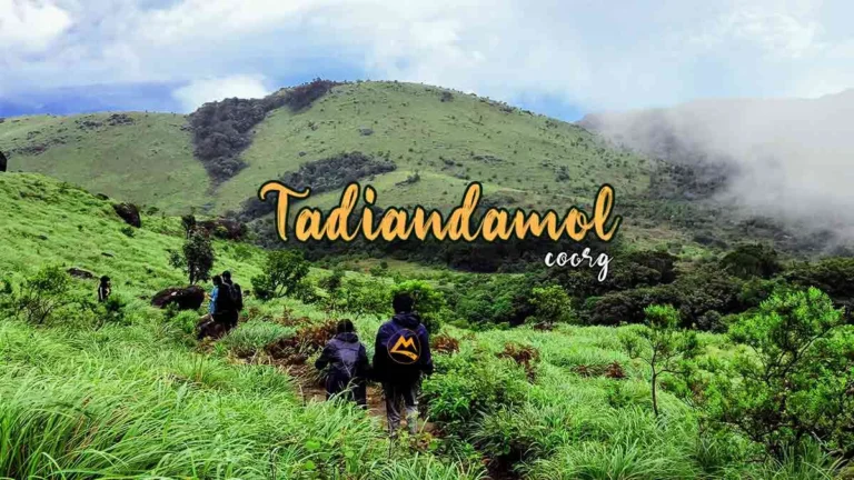
At about 1,748 metres, Tadiandamol is the highest point in Coorg, and the climb to the top is the district’s best-known trek. The trail moves between pockets of dense shola forest and open grassland before breaking onto a ridge, and on a clear day the view runs across the Western Ghats toward the distant coast. This is a walk for people with some fitness, not a roadside viewpoint.
Most routes set off near Kakkabe, often from the old Nalknad Palace, around 32 to 35 km from Madikeri, and the palace is worth a look at the start or finish. Depending on where you begin and whether you loop back, the trek runs 8 to 14 km and takes four to five hours of walking plus time at the summit. Our Coorg Tadiandamol trek lays out the route, the kit and the logistics from Bangalore.
The final approach follows an exposed grassy ridge where the views open up, and the same openness is why mist can make the way hard to read near the top. Going with a guide or a group takes care of both the route-finding and the stretches where the path fades into grass. Camping near the summit has been limited at times for conservation, so check before planning to stay overnight.
The walk itself changes character as you climb. Early on you pass through coffee and cardamom before the path enters patches of thick shola forest, dark and damp, where you tend to hear more wildlife than you see. Higher up the trees give way to open grassland that rolls toward the summit, and in places the grass is shoulder-high. The last pull to the top is steep but short, and the summit is a broad, breezy crown rather than a sharp peak. On a clear day the reward is a long view across the folds of the Ghats, which on the very best mornings reaches toward the faint line of the coast.
Clear months from September to February are best, when the grass is green and the air is sharp; the monsoon brings slick ground and leeches, so if you go then, long socks and some salt help. Set off early so you top out before the midday cloud and are back down in daylight, and carry at least two litres of water, something to eat and a layer for the wind on top. Whatever you take up, bring it back down, because there is nowhere on the mountain to leave it.
Quick facts.
Distance from Madikeri: about 55 km (north Coorg, near Somwarpet).
Access: short, steep stepped descent from the parking area.
Best time: monsoon to post-monsoon (July to November) for full flow.
Mallalli Falls sits in the quieter north of Coorg near Somwarpet, where the Kumaradhara river drops in two stages down a wooded gorge. It sees mostly weekend day-trippers rather than tour crowds, and the river that feeds it runs on toward the pilgrim town of Kukke Subramanya, so the area carries a little religious weight alongside the scenery.
From the car park a short but steep flight of steps leads down to a railed viewing platform, so you can take in both tiers without scrambling over rocks. Being up north, it fits naturally with Honnamana Kere and the Pushpagiri country for anyone working that side of the district. Our Mallalli Falls guide has the directions and the timing.
The falls are about 55 km from Madikeri, out past Somwarpet and the northern estates, reached on narrow rural roads with few fuel stops, so fill the tank and leave early. This is offbeat country with little in the way of facilities, so carry water, food and cash, and expect a small parking or entry charge near the base.
The falls come in two main drops, the upper one slim and the lower one broader, and in full flow the spray drifts back up the gorge toward the platform. The surrounding country is working farmland, with coffee, paddy and pepper rather than resorts, so the drive in gives you a look at a quieter, more rural Coorg than the Madikeri belt. Weekends bring a steady trickle of day-trippers from Somwarpet and beyond, but on a weekday you may have the viewpoint largely to yourself. There are usually a few stalls selling tea and snacks near the top of the steps, though it is wise not to count on finding them open.
July to November is the window, when the Kumaradhara is in spate and the falls actually roar; by the dry season the flow drops away and the trip stops being worth the drive. The platform keeps you safely back, which matters, because the rocks above the water turn lethal when wet and there have been accidents here. Signage is thin on the ground, so a clear set of directions or someone who knows the way saves a lot of guesswork on the last few turns.
Quick facts.
Distance from Madikeri: about 50 to 75 km (south Coorg, near the Kerala border).
Timings: about 8 am to 5 pm.
Entry: around 50 rupees per person.
Best for: a scenic cascade with a temple and trek access.
Iruppu Falls lies deep in the south of Coorg, close to the Kerala border, and it draws both sightseers and pilgrims. The water comes down the forested hillside in two main drops, and at the base stands the Rameshwara temple, an old Shiva shrine. Local legend ties the river here, the Lakshmana Tirtha, to an arrow Lakshmana is said to have fired into the hill to find water for Rama, which is why the spot is held sacred.
The falls are 50 to 75 km from Madikeri depending on the road, so the round trip eats most of a day; leave early and plan lunch around the drive. From the car park it is about a kilometre on foot, with a modest set of steps, to reach the water. Our Iruppu Falls guide covers the approach and what to expect at the other end.
Opening hours run roughly 8 am to 5 pm, with entry of around 50 rupees and perhaps a small parking charge, and there are basic stalls near the gate. One quirk to watch for: drivers or touts sometimes claim the falls are shut because of a landslide to steer you somewhere else, so check at the official counter rather than taking their word. The temple is active, so dress modestly if you plan to step inside, and expect crowds at Shivaratri.
The paved path up to the falls runs through good forest and is manageable for most visitors, ending at viewing points where the two cascades come into full view. At the base, the Rameshwara temple is a genuine working shrine, and devotees come to bathe in the Lakshmana Tirtha before worship, so you will often see rituals under way. The deep-south setting means the air is heavy and the greenery dense, and you are more likely to hear birdsong and running water than traffic. Weekends and festival days, Shivaratri above all, bring large crowds, so a weekday visit is calmer and easier to park at.
The flow is heaviest in the monsoon, though the trail and rocks are slick and the weather wet, so October to February usually gives the better mix of good water and comfortable conditions. The forest here is thicker and wilder than central Coorg, and from the falls a permitted trail pushes on into the Brahmagiri range toward camps like Narimale. If that tempts you, sort the forest department permit before you arrive rather than hoping to arrange it on the day.
Quick facts.
Distance from Madikeri: about 44 km (near Bhagamandala).
Altitude: around 1,276 m on the Brahmagiri slopes.
Timings: about 6 am to 6 pm.
Best for: the source of the river Kaveri and ridge views.
Talacauvery marks the source of the Kaveri, high on the Brahmagiri slopes near Bhagamandala, and it is one of the more revered sites in Karnataka. A small temple complex surrounds a square tank, the Brahma Kundike, where the river is believed to rise as a spring before slipping underground and surfacing again downstream. Alongside the main shrine stand smaller temples to Agastheeswara and Ganesha.
The site sits about 44 km from Madikeri and 9 km above Bhagamandala, with which it is almost always paired on a half-day run. A flight of steps climbs from the tank to a point on the Brahmagiri ridge, a short effort for a long view over folds of hills. At around 1,276 metres it is noticeably cooler and windier up here than down in town, so a light layer helps.
The complex is open roughly 6 am to 6 pm, with no real entry fee beyond the usual temple customs, and a few stalls sit near the base. The standout day is Tula Sankramana, usually in mid-October, when a spring is believed to well up in the tank at an exact moment and large crowds gather to collect the water. Outside the festival it is a calm, unhurried place.
For pilgrims the draw is the tank, where many take holy water home, and the smaller shrines around it see a steady flow of devotion through the day. For everyone else the highlight is the short climb up the steps behind the complex to the ridge, where the hills of the Brahmagiri range fall away on all sides and the air is thin and cool. The site can feel almost deserted on a quiet weekday morning and packed on a festival or weekend, so the mood varies a lot with timing. Clouds move fast at this height, and a clear view can close to white mist within minutes, which is part of the character of the place.
Clear post-monsoon and winter mornings give the best of the ridge view, while the monsoon can wrap the whole site in mist and hide it entirely. Early in the day you get soft light and the fewest people. Treat it as the place of worship it is, expect to leave your shoes at the edge of parts of the complex, and give yourself an hour or two so you can take in Bhagamandala on the same trip.
Quick facts.
Distance from Madikeri: about 36 km.
Known for: the Triveni Sangama confluence and the Bhagandeshwara temple.
Best for: a pilgrimage stop en route to Talacauvery.
Bhagamandala is a temple town about 36 km from Madikeri, built around the Triveni Sangama, where the Kaveri meets the Kannike and the mythical Sujyoti. A dip at the meeting of the rivers is considered auspicious, and many come specifically to perform rites for ancestors, so parts of the riverbank are often given over to ceremonies.
The Bhagandeshwara temple is the centre of it all, a group of shrines under sloping, Kerala-style tiled roofs with copper detailing, set around courtyards and dedicated to Bhagandeshwara, Subramanya, Vishnu and Ganapathi. The town has been a halt on the pilgrimage to the Kaveri’s source for centuries, so it keeps a steady devotional rhythm rather than a tourist bustle. The drive up from Madikeri climbs through coffee estates and forest and is pleasant in itself.
The temple and the confluence are open through the day, with the usual hours for the inner shrines and no real entry charge. Simple eateries in town serve Kodava and South Indian vegetarian meals, which makes Bhagamandala a handy lunch stop on the way up to Talacauvery. A weekly market pulls in farmers from the surrounding hills and is worth a look if your timing lines up.
The temple complex is worth a slow look for its architecture, with the sloping tiled roofs and carved woodwork typical of the older temples of the region, and a calm, lived-in feel rather than a staged one. At the confluence itself, steps lead down to the water where priests help pilgrims with offerings and last rites for departed family, a quiet, serious scene that visitors should watch from a respectful distance. The town sits in a green river valley ringed by hills, and outside festival days it moves at an unhurried pace. It is the kind of stop that rewards a little patience rather than a quick photo and a dash onward.
The post-monsoon and winter months are kindest for the drive and the views, while the monsoon swells the three rivers and deepens the meaning of the confluence for pilgrims, at the cost of wet weather and slower roads. Dress modestly, keep clear of private rituals at the water, and carry cash for offerings and small buys. Since the source at Talacauvery is only nine kilometres further up, the two are best done as a single, unhurried half day.
Quick facts.
Location: centre of Madikeri town.
Entry: free (some buildings may be restricted).
Best for: a short dose of Coorg’s royal and colonial history.
Madikeri Fort sits in the middle of town and is the easiest piece of Coorg’s history to reach. First raised in the late 17th century by Mudduraja and later rebuilt in stone, it changed hands between the Kodava kings, Tipu Sultan, who briefly renamed the town Jaffarabad, and the British, and the layers of that story are still inside its walls.
Within the grounds you will find the old palace, now government offices and a small museum, a clock tower, the colonial St Mark’s Church, and a pair of life-size masonry elephants by the entrance that everyone stops to photograph. The museum, housed in the church, holds weapons, archaeological finds and British-era odds and ends that put the surrounding region in context.
Entry to the grounds is free, and because the fort stands at the centre of town it is a short walk from Raja’s Seat, the Omkareshwara temple and the market. That makes it the natural first stop when you arrive, and you can fold it around a meal or some shopping without any extra travel. The museum and some buildings keep their own hours and shut on certain weekdays and holidays, so check ahead if the museum is your main reason for coming.
Wandering the ramparts gives you glimpses over Madikeri’s rooftops and the hills beyond, and the two stone elephants near the entrance are the most photographed corner of the fort. St Mark’s Church, a plain colonial building inside the walls, now holds the museum, whose collection runs from old weapons and inscriptions to British-era odds and ends, enough to fill twenty minutes or so. The grounds still serve as an administrative hub, so you will see government offices in use alongside the historic structures, a slightly odd mix of past and present. It is not a grand fort in the Rajasthan sense, but for understanding who ruled Coorg and when, it does the job well.
A relaxed look round takes under an hour, and the fort works at any time of year. Parts of the complex are working government premises, so stick to the open areas and follow the signs on where photography is allowed. For the time it takes, it gives you the clearest single thread through Coorg’s past before you head out to the hills.
Quick facts.
Location: Madikeri town.
Timings: about 6:30 am to 12 pm and 5 pm to 8 pm.
Entry: free.
Best for: distinctive architecture and a quiet town visit.
The Omkareshwara Temple in Madikeri is the most unusual-looking temple in Coorg. Lingarajendra II built it in 1820, by tradition to settle the spirit of a Brahmin he had wronged, and a Shiva lingam is said to have been brought from Kashi and installed here. What catches the eye is the architecture: a central dome and four minarets that read as Indo-Islamic, set against Gothic-style arches and a conventional temple sanctum.
The temple stands around a rectangular tank fed by a spring, with a small mantapa in the middle reached by a causeway and a population of fish that children like to feed. From a distance the silhouette looks almost like a mosque, which surprises most first-time visitors. Even travellers who do not usually seek out temples tend to find the building worth the short stop.
It opens in two sessions, roughly 6:30 am to midday and again from about 5 pm to 8 pm, so plan around the midday close, and there is no entry fee. The temple sits a short walk from Madikeri Fort and the market, which puts it on the same easy town circuit as the fort and Gaddige. On festival days the hours can shift and the crowds grow, so confirm locally if you are visiting around one.
Up close the mix of styles is striking, with the domes and minarets giving the building a silhouette unlike any other temple in the district, and the detailing around the sanctum repaying an unhurried look. The tank around it is the calm heart of the place, with the small central mantapa reached by a short causeway and the fish rising for scraps thrown by children. Being tucked just off the market streets, it is an easy place to step into for a few quiet minutes between other errands in town. Mornings and evenings, when the prayers are on and the light is soft on the water, show it at its best.
As a working shrine it asks for modest dress and bare feet in the inner areas. Early morning or the evening session are the better times, when prayers may be under way and the tank is quiet. Being largely under cover, it also makes a reliable fallback if an afternoon turns wet, and half an hour is enough to take it in before moving on.
Quick facts.
Location: Madikeri town.
Entry: around 10 rupees per person.
Best for: royal tombs with distinctive domed architecture.
Gaddige, or Raja’s Tomb, is a cluster of royal tombs on a rise in Madikeri and one of the town’s quieter corners. Built in the early 19th century, the monuments hold the remains of the Kodava kings Doddaveerarajendra and Lingarajendra, along with the royal guru Rudrappa, each under its own dome.
The design is the reason to come. Bulbous domes, corner turrets and ornamental detailing give the tombs a look more often tied to Islamic memorials than Hindu ones, the same Indo-Saracenic style the Haleri rulers used at the Omkareshwara temple. The whitewashed structures sit on a hill with views over the town and the greenery around it.
A road brings you most of the way, followed by a short climb of steps up to the tombs, where a small charge of around 10 rupees applies. There is little else here in the way of facilities, so it is a brief, focused stop rather than somewhere to linger. Because it sits off the main tourist flow, it is usually calm, which is part of its appeal for anyone drawn to architecture, photography or the line of Coorg’s former kings.
Up close the tombs are larger than they look from the road, their domes and turrets freshly whitewashed and set off against the green hills behind. The largest holds the two kings, while a separate structure marks the resting place of the royal guru, and there is enough carved detail to interest anyone who has already seen the Omkareshwara temple and wants to trace the same style. The hilltop setting is breezy and open, with views back over the town, and the quiet is a welcome change from the busier sights. It is a place to slow down for a few minutes rather than rush through, and it photographs particularly well in low light.
The tombs can be seen at any time of year, and the visit takes well under an hour. Morning and late afternoon give the softest light for photographs, and the steps can be slippery after rain, so take care in the monsoon. It slots neatly onto a town day with the fort and the temple, and rounds out the trio of Madikeri’s historic sights without any real detour. A small garden and a few benches near the tombs make it easy to pause for a few minutes before heading back into the bustle of the town.
Quick facts.
Distance from Madikeri: about 29 km (around 3 km from Kushalnagar).
Timings: about 9 am to 5 pm.
Entry: around 10 rupees per person.
Best for: an easy river island outing for families.
Nisargadhama is a wooded river island on the Kaveri near Kushalnagar, reached across a swaying rope-and-plank footbridge that is half the appeal. The Kaveri splits around some sixty-odd acres of bamboo, sandalwood, teak and rosewood, kept as an eco park by the forest department, and the flat, shaded paths make it one of the gentlest outings in Coorg.
Inside there is a small deer park, a peacock enclosure, plenty of birdlife and simple play equipment for children, along with a captive elephant that is sometimes available for short rides. Coracle rides on the river are a popular add-on. The island sits about 3 km from Kushalnagar and 29 km from Madikeri, which puts it on the same easy loop as the Golden Temple and Dubare.
It opens roughly 9 am to 5 pm, with a small entry fee of around 10 rupees and separate charges for the coracle and other activities. There are a few cottages on and near the island, some run by the forest department as treehouse stays, and a couple of upmarket resorts along the same stretch of river for anyone who wants to stay close to the water.
Once across the bridge, the paths wind through tall bamboo and stands of teak and rosewood, cool and shaded even at midday, with the river never far away. The deer and peacocks are easy wins for children, and the coracle rides on the Kaveri are a gentle highlight, spinning slowly on the current with a boatman at the paddle. Benches and open clearings make it a pleasant spot to sit for a while rather than march through, and the whole island is flat and easy underfoot. On a weekday outside the monsoon it can be remarkably peaceful, with birdsong and the sound of the river doing most of the talking.
The bamboo keeps the paths cool, so it works well in the middle of the day when other spots are hot. In peak monsoon the river can rise and close off parts of the island, so check conditions in the wettest months; the rest of the year it is green and calm. The lack of any climbing makes it a good choice for groups with children or older members, and an hour or two is plenty to see it at an easy pace.
Quick facts.
Location: near Somwarpet, north Coorg (about 6 km from Somwarpet).
Known for: the largest natural lake in Coorg and a lakeside temple.
Best for: a quiet, offbeat lake stop.
Honnamana Kere is the largest natural lake in Coorg, out in the north near Somwarpet, and it is visited more by locals and pilgrims than by tour groups. The name comes from Honnamma, a young woman believed to have given her life for the good of the region, and the lakeside temple to her is an important local shrine.
Ringed by hills, paddy fields and coffee, the lake is part of the working countryside rather than a packaged attraction, which is exactly why it draws people after something quieter. The annual Gowri festival here is a big event for the surrounding villages, bringing crowds to the water, but for most of the year it is calm enough to sit and watch birds. Pedal or rowing boats may be available depending on the season and the water level.
It lies about 6 km from Somwarpet town, in the same northern belt as Mallalli Falls and the Pushpagiri hills, so it makes most sense as part of a trip into north Coorg rather than a journey on its own. Facilities are basic in keeping with the setting, so bring water and snacks and do not count on finding much on site.
The lake is broad and still, backed by low hills and framed by paddy and coffee, and a short path runs along part of the bank past the temple. The water and the quiet are the attraction, so this is somewhere to sit for a while, watch the birds working the shallows and take in a slice of rural Kodagu that most itineraries skip. The temple to Honnamma on the bank is modest but important to the villages around, and during its festival the whole place changes character with crowds and ritual. For most of the year, though, you are likely to share it with a few local families and the occasional birdwatcher.
Post-monsoon and winter are the pleasantest months, with green hills and easy weather, though the lake is quietly worth the stop at any time. The roads in are narrow and rural, so allow extra time and set out early. Honnamana Kere suits travellers who would rather see a slower, lived-in side of Coorg, and if you visit the temple, treat its customs with the respect the locals do.
Quick facts.
Distance from Madikeri: about 36 to 40 km (south Coorg, near Kakkabe and Virajpet).
Best for: an offbeat waterfall near the Tadiandamol route.
Chelavara Falls, known locally as Embepare, sits off the tourist trail in south Coorg, where a tributary of the Kaveri spills down a tall, sloping rock face. It looks different from the curtain-style falls elsewhere in the district, spreading over a broad cliff rather than dropping in a single sheet, and it stays far quieter than Abbey or Iruppu.
A short walk from the car park brings you to a viewpoint, and the rocks around the falls can be explored with care, though there are no railings or built-up platforms here. The falls sit close to Kakkabe, Nalknad Palace and the start of the Tadiandamol trek, and near the Kabbe hills, an area known for short walks and estate stays, so they are best folded into a wider day in the south rather than made a trip on their own.
The falls are about 36 to 40 km from Madikeri, reached down narrow plantation lanes, so drive carefully, allow extra time and fuel up first, since there is little nearby. Bring your own water and food. The appeal here is the raw, undeveloped setting among forest and coffee, which is also the reason to take the terrain seriously.
The falls spread wide over a smooth, tilted sheet of rock and drop into the forest below, and from the viewpoint you take in both the cascade and the green country rolling away beyond it. The surrounding area, near the Kabbe hills, is a patchwork of coffee estates and forest with a scattering of homestays, and it rewards a slow drive as much as the falls themselves. There is a real sense of being off the beaten track here, with no ticket counter, no railings and few other people, which is the appeal and the catch in equal measure. The rock near the top is deceptively slick, so it is a place to look rather than clamber.
July to November, during and just after the monsoon, is when the falls are at full strength, with the weeks after the rains offering the best mix of water and surer footing. The sloping stone above the drop turns treacherous when wet, and there have been serious accidents at Coorg waterfalls from people edging onto it for a photo, so keep well back from the lip. Come here for the quiet and the scenery, because a managed, railed-off attraction is not what Chelavara is.
Quick facts.
Distance from Madikeri: about 15 km (between Madikeri and Kushalnagar).
Best for: a quiet picnic and sunset by the backwaters.
Chiklihole Reservoir is a small dam tucked between Madikeri and Kushalnagar, the kind of place that rarely makes a standard itinerary. Built across the Chiklihole river, a tributary of the Kaveri, it is a modest irrigation reservoir whose draw is simply the calm water set against green hills.
The still backwaters mirror the sky at dawn and dusk, which makes this a quietly rewarding spot for photographs and birdwatching, with waterbirds often working the margins. There is almost no commercial development, so you tend to share it with a few local families rather than a crowd. It is somewhere to bring a picnic and let an hour pass rather than tick off a landmark.
The reservoir lies about 15 km from Madikeri, with Nanjarayapattana the nearest town, and sits roughly on the route toward Kushalnagar, so it drops easily into a day that also takes in Dubare, Nisargadhama or the Golden Temple. There are no facilities on site, so carry what you need and take your rubbish away with you.
The reservoir is small and low-key, with a simple bund and a spread of still water that catches the colour of the sky at either end of the day. Scrubland and farmland surround it rather than forest, so it has an open, airy feel, and the quiet makes it good for an early walk or a lazy sit with a flask of coffee. Herons, egrets and other waterbirds are regulars along the edges, and in the soft light of early morning the place has a stillness the busier sights never manage. It will not fill more than an hour, but as a pause between the Kushalnagar attractions it does its job nicely.
It is at its best through the post-monsoon and winter months, when the water is high and the hills are green, and late afternoon into sunset is the time to be there. As a working reservoir it comes with the usual cautions: no swimming, keep away from the dam structures, and mind the water’s edge if children are along. Small and unhurried, it is for travellers who like finding the gaps between the busy sights rather than only the sights themselves. If you are driving between Madikeri and the Kushalnagar cluster, it costs you almost nothing to pull in for twenty minutes and see whether the light and the birds are out.

Quick facts.
Distance from Madikeri: about 36 km (near Kushalnagar / Hudgur).
Best for: a short stop at a large reservoir with a garden.
Harangi Dam holds back the Harangi river, a tributary of the Kaveri, and was one of the first big dams built in the Kodagu stretch of the river system, finished in the early 1980s. It supplies irrigation water downstream, and for visitors it is a straightforward stop with a garden and a wide view over the reservoir and the hills behind it.
When the reservoir is full and the gates are opened, the rush of released water is the dam’s most striking moment, though whether you catch it depends entirely on the rains and the release schedule. The rest of the time it is the broad sheet of water and the quiet garden that bring families, and it stays far calmer than the headline attractions.
Harangi lies about 36 km from Madikeri, out near Kushalnagar, close enough to Dubare to pair with it, and together with Nisargadhama and the Golden Temple it fills out a day on that side of the district. There is no real entry charge, and facilities are limited, so bring water and snacks. A viewing area looks over the spillway and the spread of backwaters.
From the dam wall and the viewing area you look out over a wide sheet of water held between low hills, and the scale of the reservoir is the main impression most visitors take away. The garden below the dam is a simple affair where families spread out for a while, and vendors sometimes sell snacks near the gate. After a strong monsoon, catching a gate release is a genuine spectacle, with water thundering down the spillway, though it comes down to luck and timing rather than anything you can plan. The rest of the year it is a calm, open spot that suits a short break more than a long visit.
The most rewarding time to come is after a strong monsoon, when the reservoir is full and a release may be on, with the post-monsoon and winter weather making the visit comfortable. As with any dam, read the signs, stay in the permitted areas and keep clear of the release zones. It is worth building into a Kushalnagar-side day rather than driving out for it on its own, which is how most people end up seeing it anyway. The open setting and the breeze off the water make it a pleasant place to stretch your legs and let children run around between the busier stops nearby.
Quick facts.
Location: on the Coorg and Mysuru border, adjoining the Kabini backwaters.
Safaris: roughly 6 am to 9 am and 3 pm to 6 pm, in slots.
Entry: safari charges apply; book through the forest department.
Best for: wildlife and tiger-reserve safaris.
Nagarhole National Park runs along the edge of Coorg where it meets Mysuru district, and it is one of the finest wildlife reserves in South India. Also called the Rajiv Gandhi National Park, it takes its older name from the local words for snake and stream, after the winding waterways through its forests. It forms part of the Nilgiri Biosphere Reserve and the Project Tiger network, and alongside Bandipur and the reserves across the Kerala line it makes up one of the country’s most important wildlife belts.
You see the park on a forest department safari, run by jeep or a larger bus, in morning and evening slots that fall broadly within 6 to 9 am and 3 to 6 pm. The exact timings and fees are revised from time to time by the Karnataka forest department, so treat any published figure as a guide. Report at the gate well ahead of your slot, bring a government photo ID, and be ready for a safari to be called off at short notice for weather or other reasons.
The park is reached most easily from the Kabini side and is usually done as a dedicated outing or an overnight from the resorts near the backwaters, rather than a quick stop from Madikeri. Kabini is especially known among wildlife watchers for the large gatherings of elephants in summer and for rare sightings of the black panther. Slots and vehicle numbers are limited, so book ahead through the official channels or your stay, particularly at weekends and in season.
A typical safari runs for a couple of hours through a mix of forest and open ground, and even on a quiet drive you are likely to see herds of spotted deer and gaur, plenty of elephants, and perhaps wild dogs or a sloth bear. The Kabini backwaters draw big concentrations of wildlife in the dry months, which is why serious photographers return here year after year, some chasing a glimpse of the famous black panther. Guides and drivers know the territory well and read alarm calls and fresh tracks to improve your chances. Even without a big cat, a drive through this forest, loud with birds and alive with movement, is rarely a disappointment.
The drier months from October to May generally bring better sightings, with summer strong as animals crowd the shrinking water, while the monsoon is green but disrupts safaris. Wear muted colours, keep the noise down and bring binoculars if you have them, since the birdlife alone, running to hundreds of species, tends to make a drive worthwhile. Big-cat sightings are never promised, so go for the forest itself and treat a tiger or leopard as the bonus it is.
Quick facts.
Location: north-west Coorg.
Trek: Kumara Parvatha, a long and challenging climb.
Permit: registration at the forest checkpost; local guide recommended.
Best for: serious trekkers and biodiversity.
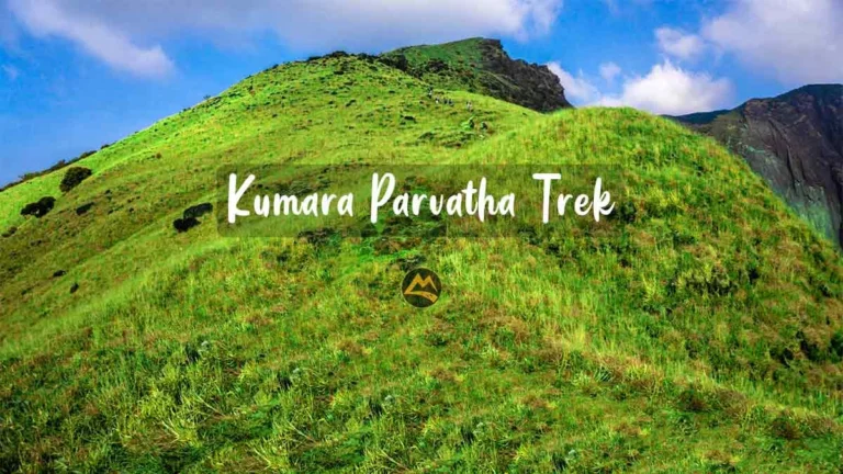
The Pushpagiri Wildlife Sanctuary protects a stretch of the Western Ghats in north-west Coorg, and among trekkers it is known for Kumara Parvatha, often rated the second highest peak in Karnataka and one of its hardest climbs. The sanctuary is rich in Ghats wildlife, including endemic amphibians and birds, and forms part of a UNESCO-listed stretch of the Western Ghats.
Kumara Parvatha, with Pushpagiri as one of its high points, is a demanding multi-hour 20km climb that gains significant height and is done in a single day. Camping was allowed earlier but it has been banned now. It is strictly for fit, experienced walkers, and the terrain and distances are considerably harder than the Tadiandamol trek. The views from the top, across ridge after ridge of the Ghats, are the payoff. Limited permits are allowed each day, so that has to be pre-booked and it costs INR 350/- per person. One common approach begins from the forest checkpost near Heggademane, with rest points along the way. Campfires and littering are prohibited in the sanctuary, and group sizes may be regulated for ecological reasons.
The trek is best attempted in the post-monsoon and winter months, when the trail is drier and the weather clearer, roughly October to February. The monsoon brings leeches, slippery paths and poor visibility and is best avoided. Carry plenty of water or a means to purify it, enough food, warm layers for the exposed sections and proper trekking shoes, and start very early. Because conditions and rules in protected areas change, confirm the current registration requirements and any restrictions with the Karnataka forest department before you go, and never trek alone here.
The sense of achievement at the top is real, and so is the effort of getting there, since the descent is as hard on the legs as the climb. This is firmly a trek for those who have done a few before and come properly prepared, rather than a first outing to test the idea.
Quick facts.
Location: south Coorg, bordering Wayanad in Kerala.
Trek: Brahmagiri peak, from near Iruppu Falls, about 10 to 12 km.
Permit: required from the forest department.
Best for: a forest trek with ridge and grassland views.
The Brahmagiri Wildlife Sanctuary covers the hills along Coorg’s southern boundary with Wayanad in Kerala, a mix of evergreen forest, grassland and high ridge that gives the range its name. It shelters elephants, gaur, sambar and a good deal of birdlife, and for most visitors the Brahmagiri peak trek is the way in.
The trek usually starts near Iruppu Falls and runs about 10 to 12 km through forest before opening onto the grassy ridgeline near the top, with the Wayanad country spread out across the state line. It typically passes a forest camp at Narimale, and the range links, over the border, to the Pakshipathalam area on the Kerala side, which marks it out as a continuous wildlife corridor rather than an isolated hill.
A permit from the Karnataka forest department is required and is usually arranged through the range office, so this is a trek to plan ahead for rather than turn up for, and group sizes may be capped for conservation. A guide helps with the route. The forest here feels genuinely remote, a product of both the terrain and the protected status.
The route starts gently through forest near Iruppu before climbing to the open grassland of the ridge, where the land drops away into Kerala on one side and Karnataka on the other. Narimale, the forest camp along the way, is a common overnight point for those doing the longer version, set in a clearing surrounded by shola forest. The high grassland is classic Western Ghats habitat, wind-blown and treeless, with the occasional herd of gaur or deer in the distance. It is a varied and genuinely wild trek, which is both its appeal and the reason the forest department keeps numbers and access under tight control.
The post-monsoon and winter stretch from October to February is the best time, with drier trails and clearer views, while the monsoon leaves the forest leech-ridden and the paths slick. Carry water, food, warm layers and proper footwear, and start early enough to finish in daylight. Because permit rules and access can change, check the current requirements and the right forest office before you set out, and once on the trail, stay with your guide and the marked route.
Quick facts.
Location: near Madapura, between Somwarpet and Madikeri.
Trek: a moderate climb to a hilltop shrine.
Best for: an offbeat trek with grassland views.
Kote Betta is one of the higher peaks in Coorg, often called the third highest, and it makes a quieter alternative to the better-trodden Tadiandamol. The name means fort hill, a nod to its old strategic position, and a small Shiva temple near the summit still draws local devotion, with a modest fair at certain times of year.
It lies near Madapura, in the belt between Somwarpet and Madikeri, and the climb runs up through coffee estates, patches of forest and open grassland to the hilltop shrine. Part of the way can be covered by vehicle on a rough track, after which you walk the rest. Because far fewer people come here than to the headline treks, the hill feels more like a working rural corner than a tourist route, and the summit opens up wide views toward the Pushpagiri hills.
There is little formal infrastructure on the trek, so bring your own water and food, and think about a guide, because the trails are not always well marked and the last stretch can be confusing in mist. Mobile signal is patchy across the area. The reward for the extra effort is solitude, which is in short supply at the more famous peaks.
The walk up moves through estates and forest before the land opens into grassland near the top, where the small temple sits and the views stretch across to the higher Pushpagiri hills. Being so lightly visited, the trail has a quiet, almost private feel, and on many days you will meet more cattle than people. The grassland can be deceptive in poor light, with few landmarks to steer by, which is why local knowledge is useful on the upper section. For walkers who have tired of sharing the path at the well-known peaks, the solitude here is the whole point, and the modest temple fair offers a glimpse of how the hill still matters to the villages below.
October to February brings green slopes, clear views and the easiest walking, while the monsoon leaves the trail slippery and the grass full of leeches. Set off early, wear proper shoes and pack a windcheater for the open top, and keep an eye on the weather, since mist can close in fast up on the grassland. Kote Betta suits walkers who are happy with a moderate, slightly unmarked trek rather than an organised, waymarked one.
Quick facts.
Location: near Kithu-Kakkathu, south Coorg.
Season: monsoon, roughly June to September.
Rapids: Grade 2 to 4 and higher in peak flow.
Cost: around 1,000 to 1,200 rupees per person.
Best for: adventure and white-water rafting.
The Barapole, also called the Kithu-Kakkathu, is Coorg’s white-water rafting river and one of the better-known runs in South India. It rises in the Brahmagiri hills and flows west toward Kerala, where it joins the Valapattanam system, and it is the steep, boulder-choked section in the Kithu-Kakkathu area that throws up the rapids, several of them with names like Morning Coffee, Grasshopper and the Big Bang.
A typical run covers about 4.5 km and lasts an hour and a half to two hours, taking in rapids graded from around 2 up to 4 and higher at peak flow, so there is real excitement for first-timers and seasoned rafters alike, always with trained guides and safety gear. The stretch mixes fast technical water with calmer pools where you can catch your breath, set in a forested gorge with little development along the banks.
The put-in sits in the south of the district, a drive from the main towns and reached through plantations and forest, and rafting is arranged through operators who handle the transport, kit and guides. Expect to pay somewhere around 1,000 to 1,200 rupees a head, varying by operator and season. A reasonable level of fitness and the ability to follow instructions in fast water are needed, and age and health limits usually apply, so it is not for very young children or anyone with certain conditions.
The run alternates between stretches where you paddle hard through standing waves and quieter pools where the raft drifts and you take in the gorge, thick with forest on both banks. The named rapids come fast in the middle section, and a good guide will have the raft punching through the bigger drops while keeping everyone aboard. Between rapids the setting does a lot of the work, with little sign of roads or buildings along this part of the river. For many who come, it is as much about the green, dripping gorge in full monsoon as about the white water, and the two together make the short season worth planning around.
This is a monsoon-only run, roughly June to September, when the river has the water for it, which makes it one of the few Coorg experiences at its best in the rain; once the levels drop, it stops. Wear quick-drying clothes, leave anything that cannot get wet behind, and listen hard to the safety briefing. Book with a reputable, well-equipped operator and keep your plans loose, because a run can be called off at short notice when the river is unsafe.

Quick facts.
Distance from Madikeri: about 30 km (at Yavakapadi, near Kakkabe).
Known for: an 18th-century royal palace.
Best for: history and as the base for the Tadiandamol trek.
Nalknad Palace, or Nalknad Aramane, is a modest royal house near Kakkabe in south Coorg, about 30 km from Madikeri. Dodda Veerarajendra of the Haleri line built it in 1792 after escaping Tipu Sultan’s army into this remote valley, and the last king of Coorg, Chikka Veerarajendra, stayed here too before the British deposed him in 1834.
The two-storey building is plainer than grander Indian palaces, and its interest lies inside, in faded murals of royal processions, hunting scenes and floral patterns across wooden pillars and ceilings. The last king is said to have celebrated his wedding here, and a legend persists of a tunnel dug toward Madikeri as an escape route. The quiet valley setting at Yavakapadi fits a building that was meant as a refuge in wartime.
The palace sits right at the foot of the Tadiandamol trek, so many trekkers pass through or start here, and it pairs naturally with that climb or with nearby Chelavara Falls. It is a protected monument under the state archaeology department and has been restored. Opening hours and any ticket details are not reliably published, so check locally before you go and treat it as the heritage site it is.
Inside, the appeal is the quiet detail rather than any grandeur: painted pillars and ceiling panels in muted colours, carved wooden screens, and the sense of a modest royal household rather than a showpiece court. A raised pavilion and courtyard give a feel for how the building was used, and the setting, hemmed in by hills and plantations, makes clear why a king on the run chose this valley. It is rarely crowded, so you can take your time with the murals and the structure, and the caretaker, if present, may share a few of the stories attached to the place. For its size, it holds a surprising amount of Coorg’s turbulent royal history.
The post-monsoon and winter months make the drive through the plantation country most comfortable, and the journey is part of the appeal. Facilities nearby are thin, so plan fuel, food and water around Kakkabe. A look round the palace itself takes well under an hour, but for anyone interested in Coorg’s royal past it is a rare surviving piece of Haleri-era domestic architecture, and a fitting place to begin the walk up the district’s highest peak.
Quick facts.
Where: across the district, including around Madikeri, Suntikoppa, Pollibetta and Chettalli.
Experience: plantation walks, tastings and estate homestays.
Harvest season: roughly November to February.
Best for: the defining Coorg experience.
Coffee is the thread that runs through Coorg, and no trip really captures the place without some time on an estate. The district grows a large share of India’s coffee, both Arabica and the hardier Robusta, raised under a canopy of shade trees threaded with pepper vines and cardamom. That shade-grown system is part of what gives Coorg coffee its character and keeps the hills as green and layered as they are.
Many estates and estate homestays run guided plantation walks, where you follow the crop from bush to cup, how it is grown, picked, processed and roasted, usually ending with a tasting of the estate’s own coffee. For a lot of visitors the real memory is the stay itself: waking on a working plantation, eating Kodava home cooking and hearing nothing but birds. Estates cluster around Madikeri, Suntikoppa, Pollibetta and Chettalli, among them some large and historic names, so wherever you base yourself a plantation is close.
The experience scales to whatever you want, from a two-hour guided walk to a multi-day homestay, and from boutique estate resorts with pools to family-run places that feel like staying with relatives. Harvest, roughly November into the early months with Robusta trailing Arabica, is the liveliest time to see an estate at work, while the monsoon is when the coffee blossoms and the hills look their greenest. Book ahead in season and on long weekends, when the better homestays fill fast.
A good plantation walk is part lesson, part slow wander, taking you past coffee at different stages, pepper vines spiralling up the shade trees, and the drying yards where the beans are raked out in the sun. Many hosts roast and brew their own, so you often finish with a cup made from beans grown within sight of where you are sitting. Estate stays tend to run on home-cooked Kodava meals, pork curry and rice dumplings among them, and long, unstructured hours with little to do but walk, read and drink coffee. It is the part of a Coorg trip that people most often say they wish they had given more time to, rather than rushing between viewpoints.
Buying coffee, pepper and wild honey straight from the growers is both a good thing to take home and a way to put money back into the estates whose hills you have come to enjoy. If you would rather not piece the trip together yourself, our Coorg weekend trip from Bangalore is built around exactly this: the estate stay, the sightseeing and the travel handled, so the only thing left to do is settle in with a cup of the local brew.
With a weekend, this two-day plan covers the highlights at a comfortable pace, assuming you arrive the night before Day 1. Adjust the order to suit where you are staying, since the sights are spread across the district.
Day 1: Madikeri and the viewpoints
Before dawn: drive out and take the jeep up to Mandalpatti for sunrise over the clouds.
Mid-morning: Abbey Falls, then the Madikeri town sights (the fort, Omkareshwara temple and Gaddige).
Afternoon: a coffee estate walk and tasting near Madikeri.
Evening: Raja’s Seat for sunset over the hills.
Day 2: Kaveri, culture and nature
Early morning: Dubare Elephant Camp for the morning session by the river.
Late morning: the Golden Temple (Namdroling Monastery) at Bylakuppe.
Afternoon: Nisargadhama river island, or a waterfall such as Iruppu or Mallalli depending on your route home.
Prefer to have the stay, travel and sightseeing organised for you? Our Coorg weekend trip from Bangalore packs the best of this itinerary into an easy group getaway.
Coorg is a year-round destination, but the experience changes a lot by season, so match your timing to what you want to see.
October to March (winter and post-monsoon): the most popular window, with cool, clear weather, green hills and comfortable days, ideal for sightseeing, viewpoints and treks like Tadiandamol. This is peak season, so expect crowds and higher prices on weekends.
June to September (monsoon): the waterfalls are at their fullest, the coffee is in bloom and the hills are intensely green, and it is the only season for rafting on the Barapole. The trade-offs are heavy rain, mist that can hide viewpoints, slippery trails and leeches on treks.
April and May (summer): warmer but still pleasant in the hills, with fewer crowds and lower waterfall flow by late summer. It is a good time for wildlife at Nagarhole, when animals gather near shrinking water sources.
By road: Madikeri, the main town, is about 260 km from Bangalore, usually around five to six hours by car via Mysuru on NH275 (longer with traffic or stops). Overnight KSRTC Volvo buses also run from Bangalore to Madikeri and take roughly six hours.
By train: there is no railway station in Coorg itself. The nearest railheads are Mysuru (about 120 km from Madikeri) and Hassan; from either you continue by road.
By air: the nearest airports are Mysuru (limited flights) and Mangaluru (about 135 to 160 km). Most travellers fly into Bengaluru and drive in from there.
Within Coorg there is no real public transport to the scattered sights, so a private car, cab or an organised trip is the practical way to get around, and roads to the offbeat spots are narrow and slow, so plan generous travel time between places.
Coffee estate homestays are the classic choice: you stay on a working plantation, eat home-cooked Kodava food and wake up surrounded by greenery, with options from simple family homestays to boutique estate resorts.
Madikeri town suits first-timers who want to be close to the main sights, restaurants and the bus stand, while the Kushalnagar and Siddapur side is handy for the Golden Temple, Dubare and Nisargadhama.
Somwarpet and Kakkabe in the north and south are quieter bases for Mallalli Falls, Honnamana Kere, Tadiandamol and Nalknad Palace. Book well ahead on long weekends and in peak season, when Coorg fills up fast.
Two days cover the main sights comfortably on a weekend from Bangalore. Three days let you add a trek such as Tadiandamol or explore the quieter north and south without rushing.
Coorg is famous for its coffee estates, misty Western Ghats scenery, waterfalls like Abbey, Iruppu and Mallalli, viewpoints such as Mandalpatti and Raja’s Seat, the Golden Temple at Bylakuppe, and Kodava culture and cuisine.
October to March for clear weather, views and treks; June to September for full waterfalls and rafting; April and May for fewer crowds and better wildlife sightings. Winter is the most popular season overall.
Madikeri is about 260 km from Bangalore, roughly five to six hours by road via Bengaluru – Mysuru Expressway.
Yes. Dubare Elephant Camp, Nisargadhama, Raja’s Seat and coffee estate stays are all family-friendly. A few waterfalls and treks involve steep or slippery paths, so plan around the ages and fitness of your group.
Yes. Private vehicles are not allowed on the final rough stretch, so you take a shared four wheel drive jeep from the base, usually arranged near Raja’s Seat in Madikeri.
Abbey Falls near Madikeri is the most famous and easiest to reach. Iruppu in the south and Mallalli in the north are both spectacular during and just after the monsoon, and Chelavara is a good offbeat option.
Coorg is generally considered safe. As anywhere, take normal precautions, avoid isolated spots and treks after dark, keep someone informed of your plans, and prefer registered guides and operators for treks and activities.
From cloud-covered viewpoints and waterfalls to Tibetan monasteries, royal tombs, wildlife safaris and slow days on a coffee estate, Coorg fits an unusual variety of experiences into one hill district. Pick the places that match your interests and the season, allow enough travel time between them, and you have the makings of a memorable trip. If you would rather have the stay, travel and sightseeing handled for you, join our Coorg weekend trip from Bangalore and simply show up for the hills.
